When a developer or architect needs an aerial view of a project, most articles frame it as a simple two-way choice: hire a drone pilot or commission a CGI render. In practice, there are three distinct aerial options — and the right one depends on where the project sits in its lifecycle, what the imagery needs to accomplish, and in some urban markets, whether a drone flight is even legally accessible.
I'll be transparent upfront: we're a rendering studio, so we have a natural interest in the CGI case. But the honest position is that these are genuinely different tools for different situations, and understanding when each wins leads to better outcomes. Here is a direct comparison of all three options.
The three aerial options
Most guides compare only full CGI versus drone photography. The composite approach — shooting an aerial photo of the real site and compositing a CGI rendering of the proposed building into it — is a distinct third option that is often the best solution for a specific range of projects. Understanding all three choices before you brief a studio prevents you from commissioning the wrong approach for your situation.
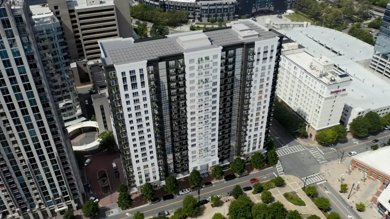
Full CGI aerial rendering — the entire environment is modeled in 3D: terrain, surrounding buildings, landscaping, roads, and the proposed development. No photography involved. The studio controls all conditions.
Drone photography — a licensed operator shoots the existing site or completed building with an unmanned aerial vehicle. Post-processing improves the image; nothing is constructed digitally.
Composite aerial — a drone photographs the actual surrounding context from a specified viewpoint; the proposed building is then rendered in CGI and composited into the real aerial photo. The environment is real; the building is constructed digitally. This approach is sometimes called a photomontage or photo-CGI composite.
Drone photography: when it wins and where it falls short
Drone photography has irreplaceable advantages in one scenario: the building exists and needs to be documented as built. A photograph of a completed structure carries evidentiary weight that no CGI can replicate. It proves the building was built, that it looks as designed in real conditions, under real light, with real surrounding context and real occupancy. This authenticity matters for portfolio submissions, award applications, press coverage, and any context where "this is what we actually delivered" needs to be credible.
Speed is a practical advantage for completed assets. A skilled operator who clears FAA authorization, arrives on site, and shoots in favorable weather can deliver processed images within 24 to 48 hours. For a finished development entering its leasing campaign, that turnaround can be valuable.
Cost for straightforward coverage of a completed property is also competitive. A standard residential drone shoot runs $250–$500 for a licensed operator; commercial architecture photography from a specialist runs $1,000–$3,000 for a half-day shoot. For documenting what exists, the cost-to-output ratio is strong.
Where drone photography falls short is equally predictable. Before construction begins, the camera has nothing useful to capture. A photograph of an empty lot or a construction site communicates almost nothing about the finished development. Pre-construction marketing — when visualization generates the most commercial return — is inaccessible to photography. And if the design changes after the shoot, the imagery is obsolete. There is no update; there is only a reshoot.
CGI aerial rendering: when it wins and where it falls short
The most powerful application for aerial CGI is pre-construction marketing: showing the project exactly as it will appear upon completion — months or years before ground is broken. Developers launching pre-sales campaigns for designs still in permitting have no alternative to CGI for aerial imagery that shows the finished vision at its best.
Total control over conditions is a significant advantage for high-stakes materials. When you commission an aerial CGI render, you specify the lighting direction, time of day, season, weather atmosphere, camera altitude, camera angle, and the level of surrounding context modeled. The image shows the project under conditions that may never occur simultaneously in reality. For a pre-sales marketing campaign where the imagery is the primary sales tool, this control over quality matters.
Design flexibility sets CGI apart from photography for projects still in active development. If the facade material changes, a floor is added, or a rooftop feature is relocated, the rendering studio updates the model and re-renders at a fraction of the original project cost. This makes CGI the correct choice for any project where the design is not fully resolved.
For large-scale developments — master-planned communities, mixed-use campuses, urban infill projects — the aerial view needs to show the complete site in a coherent, finished image. CGI renders the entire project as planned, showing multiple buildings, landscaping, and amenity zones at once, regardless of current site conditions.
The limitation of CGI for completed projects is straightforward: a photograph proves something exists; a CGI render shows what was intended. For portfolio work, press, and award submissions, photography is the standard. A CGI render of a completed building may document design intent, but it doesn't document delivery.
Composite aerial: the hybrid option most guides skip
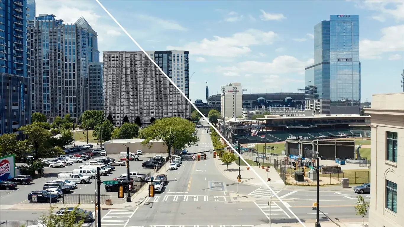
The composite approach occupies a middle ground that is the best choice for a specific range of projects: the building doesn't exist yet, but the existing site context is important and needs to look real.
The workflow requires close coordination: a drone photographer shoots the site from a pre-determined viewpoint specified by the rendering studio, who then camera-matches a 3D model of the proposed building to that photo and composites the render into the real aerial image. The surrounding buildings, streets, topography, and vegetation are real; the proposed building is constructed digitally at the correct scale, angle, and position.
Composite aerials are the right choice when:
- The project site has distinctive real-world context that adds credibility — a waterfront location, a recognized street, a well-known surrounding skyline
- Planning authorities require photomontage accuracy showing the proposed building against real surrounding context, as is standard for urban planning submissions in many jurisdictions
- The project is in an urban area where full 3D modeling of the surrounding density would be expensive and the real drone shot captures it faster and more accurately
- Budget is a constraint — composite work typically costs less than full 3D because the environment doesn't need to be modeled from scratch
The tradeoff: composite aerials are only as good as the timing of the drone shot. Neighboring buildings under construction, scaffolding, temporary signage, or unfavorable seasonal foliage in the photo backdrop are permanent parts of the composite. Full CGI gives you total control over every element; the composite gives you real context but inherits its flaws.
Airspace restrictions: the urban site factor most guides ignore
In dense urban markets, drone photography faces a practical obstacle that rarely appears in comparison guides: much of the most commercially significant real estate is in restricted or controlled airspace where flight authorization takes time, carries restrictions, or isn't obtainable at all.
In the Los Angeles market, FAA airspace restrictions apply to significant portions of the metro area. Sites within the Class B airspace surrounding Los Angeles International Airport (LAX) require LAANC authorization or a specific FAA waiver before any commercial drone flight. Dense urban areas — Century City, Downtown LA, Koreatown — sit within controlled airspace that requires advance authorization. The Hollywood Hills and coastal canyons involve terrain and infrastructure complications. A drone shoot that sounds like a 24-hour process can realistically take several days to a week to properly authorize and schedule in these zones.
FAA Part 107 certification is required for all commercial drone operations. Beyond federal requirements, California, Los Angeles County, and individual municipalities have their own ordinances — some parks and public spaces have blanket drone bans; certain private properties require landlord consent for overflights. For high-rise projects in dense urban blocks, temporary flight restrictions (TFRs) for events or emergencies can ground a planned shoot entirely.
None of this applies to CGI aerial rendering. The studio models the site, sets the camera, and renders — no authorization required, no weather windows, no permit delays. For urban infill projects in restricted airspace, or for any project where the timeline is tight, the practical logistics of drone flights can tip the decision toward CGI even when photography would otherwise be the preference.
Cost and timeline comparison
| Factor | Drone photography | Composite (photo + CGI) | Full CGI aerial |
|---|---|---|---|
| Typical cost range | $250–$3,000 | $1,500–$6,000 | $800–$8,000+ |
| Requires building to exist | Yes | No (site must exist) | No |
| Lighting and conditions | Weather-dependent | Real context, CGI building | Full control |
| Urban airspace restrictions | May require authorization | May require authorization | None |
| Update when design changes | Full reshoot required | Re-render building only | Revise model (fraction of cost) |
| Suitable for pre-construction | No | Yes | Yes |
| Planning submission accuracy | Documents existing only | Strong (real context) | Good (modeled context) |
| Turnaround from brief | 24–48 hrs after shoot | 7–14 business days | 5–15 business days |
| Best use case | Documenting completed work | Pre-construction in real urban context | Full design control, large-scale sites |
Decision framework by project stage
The right choice follows from where the project is in its lifecycle:
- Design phase, pre-permit, pre-construction — CGI or composite. There is nothing to photograph.
- Planning submission requiring photomontage accuracy — composite aerial, where regulations require the proposed building to be shown against real site context.
- Pre-sales launch, unbuilt project in a recognizable urban context — composite if budget allows; full CGI if the surrounding environment needs significant landscaping or if the context would look unflattering from a real photo.
- Active construction, marketing campaign ongoing — CGI for the marketing imagery; drone for construction progress documentation.
- Near completion or complete, entering sales or leasing phase — either CGI or drone works. CGI gives more atmospheric control; drone gives authenticity and speed.
- Complete, for portfolio and press — drone photography. The building is the story. Show the real thing.
- Urban site with airspace restrictions and tight timeline — CGI removes the permitting variable entirely.
Browse our aerial rendering portfolio to evaluate the quality of CGI aerial work before committing. For pricing and scope options across all three approaches, see our pricing page or request a free estimate — we respond within 2 hours.
Need an aerial view before construction begins?
Send us your site plans and design drawings — we'll advise on the right approach and have a free estimate back to you within 2 hours.
Request a free estimate